
Key Tips for Hiking Crooked Falls

- Short but steep: Even though it's just 5.3 km, the consistent climb and technical sections make this feel harder than the numbers suggest.
- Best in spring: Crooked Falls is most impressive during spring runoff when the creek is raging. Visit after heavy rain for maximum flow.
- Year-round access: Low elevation (490m at the falls) means this trail is hikeable in all seasons, though it can be muddy and slippery in wet conditions.
- Watch your footing: Parts of the trail run close to steep drop-offs. Rocks and roots can be slippery, especially near the falls.
- Multiple viewpoints: There are two main viewpoints at the falls: one from the side and one directly in front. The front viewpoint gets you close enough to feel the spray.
- Remote location: No cell service once you leave the highway. Make sure someone knows your plans.
- Gravel road access: The last stretch of Ashlu Road is rough with potholes. Most 2WD vehicles can make it, but drive slowly and watch for large rocks.
- Wear proper footwear: The trail is rocky and root-filled with plenty of slippery sections, especially near the viewpoints. Hiking boots with good ankle support and grip are essential.
- Bring a rain jacket: The spray from the falls will soak you, especially at the front viewpoint. Even if the weather is clear, pack a shell.
- Start early on weekends: The trailhead parking is limited to a small pullout. Arrive early to secure a spot, especially during summer weekends.
- Bring trekking poles: The steep sections and rocky terrain can be tough on the knees, especially on the descent. Poles help with balance and reduce strain.
- Check road conditions: Ashlu Main can deteriorate depending on the season and recent weather. If you're uncertain about your vehicle's clearance, call ahead or check recent trip reports.
- Pack the essentials: There's no cell service and no facilities. Bring water, snacks, a first aid kit, and let someone know your plans before heading out.
Where to Stay (Before It’s Fully Booked)
Trail Map
Hiking to Crooked Falls
| Distance | Elevation | Time | Type | Difficulty |
|---|---|---|---|---|
| 5.6 km | 472 m | 3 h | out and back | moderate |
Starting Point

The Sigurd Creek Trailhead is located along Ashlu Road in the Upper Squamish Valley, about 1.5 hours from Vancouver.
From Highway 99, turn left onto Squamish Valley Road (directly across from the Alice Lake turnoff). Follow Squamish Valley Road for about 23 km as it winds alongside the Squamish River. The pavement ends and transitions to gravel. Continue another 1.5 km to the Ashlu Creek bridge and turn left to cross it.
Once across the bridge, you're on Ashlu Main. Follow this gravel road for about 2.4 km. The trailhead is on the left side of the road, marked by a yellow sign on a utility pole that says "Sigurd Trail." There's a small pullout where you can park alongside the road next to Ashlu Creek. An easy way to remember where the trailhead is is by counting bridges. The trailhead is just past the 4th bridge you cross.
Driving Notes: The final 2 km of Ashlu Main are rough with potholes and loose rocks. Most 2WD vehicles can make it, but you'll need to take it slow and pick your line carefully. If you're not comfortable with the road conditions, you can park earlier and walk the extra distance.
)
Trail Overview


The trail begins as a steady incline with a fairly level rocky path. It's wide enough here to walk side by side with someone else. After the first 20 minutes or so, you start to gain elevation much more quickly through the lush rainforest. There are some big steps and a few spots you'll need to use your hands to pull yourself up over roots and boulders. There are a few flat sections where you can catch your breath, but it's mostly a steep climb the whole way.
As you climb, keep an eye out for a small side trail on your left that leads to a viewpoint overlooking the Squamish Valley. It's easy to miss because there's no sign, just a slightly worn path heading toward a rocky bluff. The viewpoint is worth the quick detour. You'll get sweeping views down to the Squamish River and across to the Tantalus Range. If you look carefully, you might spot the Jim Haberl Hut high up in the mountains across the valley.
After about 2 km from the trailhead, you'll reach a junction marked by a yellow sign. Go left for Crooked Falls (the right fork continues up to Sigurd Peak and Ossa Peak for more advanced scrambles). From the junction, it's only 300 meters to the falls, but the trail descends slightly through dense forest.
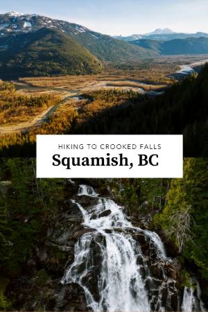
You'll hear Crooked Falls before you see it. The roar of water crashing over rock gets louder as you approach, and then suddenly you're there. The first viewpoint is tucked against a cliff wall, giving you a side angle of the falls. From here, you can see how Sigurd Creek plunges down the mountain, hits a rock bluff, and makes that signature 90-degree turn before continuing downhill.
Don't stop at the first viewpoint. Continue down a short, steep path to the second viewpoint directly in front of the falls. This is where you'll get the full experience. The water crashes down with enough force to create a constant spray that'll soak you within minutes. The ground here is slippery, and the edge drops off sharply, so watch your step and keep a safe distance from the cliff.
If you're visiting in spring or after heavy rain, the power of the falls is genuinely impressive. The spray is cold and relentless, and the sound is deafening. Even on a hot day, you'll want a rain jacket.
Why Hike Crooked Falls

Crooked Falls isn't going to show up on those "Top 10 BC Waterfalls" listicles next to Shannon Falls or Helmcken Falls. It doesn't have the height or the easy access to compete with the big names. But this is a quintessential Sea to Sky Hike: driving down gravel roads, crossing one-lane bridges, and climbing through quiet forest to reach something most people will never see.
The falls themselves are unique. That 90-degree turn mid-cascade is uncommon enough to feel special, and the multiple viewpoints let you experience the waterfall from different angles. The side view shows the full descent and the crooked flow, while the front viewpoint puts you right in the chaos of spray and sound.
The trail itself is solid. It's well-maintained, clearly marked, and challenging enough to feel rewarding without being punishing. The forest is beautiful in that classic coastal BC way, thick with moss, ferns, and old-growth character. The viewpoint overlooking the Squamish Valley is a bonus that elevates the hike beyond just "walk to waterfall and back."
If you're looking for a shoulder season hike when higher trails are still snowed in, Crooked Falls is a reliable option. If you're training for bigger objectives, the consistent climb makes it a good workout. If you just want to get out of the city for a few hours and see something worthwhile, this fits the bill.
What to Do at Crooked Falls

The main event is obviously the waterfall, but don't rush it. Spend time at both viewpoints. The side viewpoint is safer and drier, making it a good spot to eat a snack and take photos without getting drenched. The front viewpoint is more dramatic but also wetter and more exposed. If you're visiting in spring, prepare to get soaked.
There's a second, smaller waterfall along Sigurd Creek about 1.5 km past the main junction. If you have extra time and energy, you can continue up the Sigurd Trail to check it out. It's less impressive than Crooked Falls but still scenic, and you're less likely to encounter other hikers.
If you're feeling ambitious, the Sigurd Trail continues all the way to Sigurd Peak and Ossa Peak, both of which are serious scrambles with significant elevation gain (900+ meters beyond Crooked Falls). These are full-day objectives best left for experienced hikers.
After the hike, there are swimming spots along Ashlu Creek near the trailhead. The water is glacier-fed and freezing, but on a hot day, it's a refreshing way to cool off. Just be cautious of the current! Ashlu Creek is swift and powerful.
When to Visit Crooked Falls

Spring (April to June): This is peak season for Crooked Falls. Snowmelt from higher elevations feeds Sigurd Creek, turning the waterfall into a thundering spectacle. The spray is intense, and the sound is deafening. Trails can be muddy, so expect slippery conditions.
Summer (July to September): The falls are still impressive but less dramatic as water flow decreases. The trail is dry and in the best condition. This is the most popular season, so expect more hikers and limited parking. Mornings are quieter.
Fall (October to November): Water flow increases again with fall rains, bringing the falls back to life. Trails can be muddy and slippery, but the forest is beautiful in autumn colours. Fewer crowds make this a great time to visit.
Winter (December to March): The low elevation means Crooked Falls is hikeable year-round, but conditions can be challenging. Ice, mud, and wet rocks make the trail slippery. The falls can partially freeze in cold snaps, creating unique ice formations. Only experienced winter hikers should attempt this trail in snowy conditions.
FAQ
How long is the Crooked Falls hike?
Is the Crooked Falls hike difficult?
When is the best time to visit Crooked Falls?
Can I hike Crooked Falls in winter?
How do I get to the Crooked Falls trailhead?
Do I need a 4WD vehicle to reach Crooked Falls?
Is there cell service at Crooked Falls?
Will I get wet at Crooked Falls?
How crowded is the Crooked Falls trail?
Are there other hikes near Crooked Falls?
Can I swim near Crooked Falls?
What should I bring for the Crooked Falls hike?
Our Trusted Travel Partners
We only recommend products and services we personally use and trust.

SafetyWing
Travel medical insurance for nomads and remote workers
Booking.com
Find the best deals on hotels, apartments, and vacation rentals
AllTrails
Discover hiking trails with detailed maps and reviews
Surfshark
Secure VPN for safe browsing and accessing content worldwide
Get Your Guide
Find the best deals on tours and experiences
Airalo
Prepaid SIM cards for travelers
Trusted Housesitters
Find free accommodation by house and pet sitting worldwide
Wise
Send and receive money internationally with low fees* We may earn a commission when you make a purchase through our affiliate links, at no extra cost to you. We appreciate this support, which helps sustain our blog and allows us to create more content and help more great trips get planned!