
What to Know Before You Go
- Best Time to Hike: Spring and fall are the best overall seasons. Summer is beautiful, but trails can get hot during peak summer, especially on ridge hikes like Mount Erskine. Winter is still possible, because Salt Spring has relatively mild weather, but expect muddy trails and the occasional storm.
- Bring Water: No hikes outside of Ruckle Provincial Park have access to drinking water, and a few of these hikes will get you sweating, so make sure to stay hydrated.
- Wildlife: You'll mostly encounter deer, bald eagles, ravens, and seals offshore. The occasional snake turns up on rocky sections in summer. Nothing that should concern most hikers. There are no bears on Salt Spring Island, although there are rumours that one or two have swam over from Vancouver Island in the past.
- Trail Difficulty: Most Salt Spring hikes are short and easy to moderate rather than full-day alpine efforts. And I think they match the vibe of the island well. Nothing better than a quick summit, then being back down in the valley 2 hours later, sipping some cold cider in the orchard you were looking at from the top.
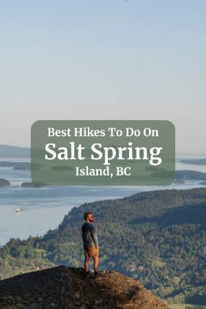
1. Mount Erskine

This is Salt Spring's signature hike, and it earns the reputation. Mount Erskine delivers the best balance of views, accessibility, and effort-to-reward ratio of any trail on the island, and the Gulf Islands scenery from the top is hard to beat.
There are multiple ways up, but the most popular route starts from the upper residential access road, which puts you much higher on the mountain from the start and keeps the hike feeling manageable. Check the AllTrails map embedded below to see the exact location of the trailhead. The trail climbs gradually through beautiful coastal forest filled with mossy trees and rocky outcrops before opening onto the viewpoints.
One thing worth knowing: the true summit isn't actually the best lookout. If you explore slightly off the main route toward the lower bluff viewpoints, you'll find better photo spots with fewer trees blocking the view and more room to sit and take it all in. It's a short detour and worth doing every time.
If you only have time for one hike on Salt Spring, make it this one.
| Distance | Elevation | Time | Type | Difficulty |
|---|---|---|---|---|
| 3.8 km | 214 m | 1.5 h | loop | moderate |
Trail Map
2. Ruckle Provincial Park Shoreline Trail

This might honestly be the best overall hike on the island, and it's a completely different experience from the other, more well-known summit hikes.
The Ruckle shoreline trail follows the rugged southeastern coast of Salt Spring with continuous ocean views, rocky bluffs, driftwood beaches, and hidden coves that appear and disappear as the trail winds along the water. This hike lends itself well to frequent stops. There are several amazing picnic areas along the rocky coast and at least a dozen little beaches you could spend the whole afternoon at.
Trail Map
If you want to extend this hike, instead of following the AllTrails, where it loops back into the farm, you can continue on up all the way to Yeo Point. This is another great viewpoint next to one of the nicest pebble beaches on this part of the coast.
The trail itself is a pretty easy hike. There are a few hills to go up and down, but it's mostly a flat seaside stroll. If you loop back through the farm, you will be walking along fenced-in areas, so your chances of seeing animals grazing along the way are high. The animals move around, and the farm puts them in different fields all the time, so I can't guarantee what you will see or if there will be any out when you pass by. But hey, if there is even a small chance of seeing some sheep, goats, or highland coos, I'll roll those dice.
3. Baynes Peak via Mount Maxwell Provincial Park

If Mount Erskine was too easy for you, give Mount Maxwell a try. Well it's still not as brutal as some of the alpine treks on the mainland, it's probably the most challenging hike on Salt Spring.
| Distance | Elevation | Time | Type | Difficulty |
|---|---|---|---|---|
| 5.7 km | 450 m | 2 h | loop | moderate |
Trail Map
There are several ways to do this hike, but the best is to follow Baynes Peak Via Armand on AllTrails (see the embedded map above). If you're going up for sunset, make sure you do the loop clockwise. There are 3 viewpoints along the trail labelled #4 that are almost better views than the peak, because the park has a big ugly metal fence all around the cliffs.
This is one of the best sunset spots on the island, but just be careful that if you stay at the peak for the full sunset, you will most likely be doing part of the hike down in the dark. The path down isn't too steep, so if you bring headlamps, you will be fine, but make sure you bring some light source because the forest gets pretty dark even in the twilight.
So, go clockwise around #4 and make sure to make the detours down to the viewpoints marked on the AllTrails and pack some headlamps if you're timing this for sunset.


I really liked this trail and the views of the farmland stretching coast to coast are amazing, but it is a bit harder than Mount Erskine, and I think the view from Erskine is more impressive. They are both great hikes, but if you only have time for one, I would pick Mount Erskine.
Also, if you don't feel like hiking, you can also drive up to the top of Mount Maxwell. We chose to hike it because we didn't want to take our Forester up the dirt road, as it is generally recommended as 4x4 only, since it is not a maintained road. But when we got to the top, we saw an old SUV and a Toyota Camry, so I assume the road isn't too bad.
4. The Chris Hatfield Trail

Ruckle Provincial Park gets a lot of attention for its camping and its coastal trail, but the Chris Hatfield Loop is its own reward and worth planning your day around.
| Distance | Elevation | Time | Type | Difficulty |
|---|---|---|---|---|
| 3.5 km | 85 m | 1.5 h | loop | easy |
Trail Map
The trail itself is mostly easy going. It's wide, clearly marked, and runs through a gorgeous old forest that runs along the coast. There are a few steeper sections with rocks and roots, but nothing that would slow down a regular hiker. That said, it's not a flat stroll, so anyone with mobility concerns should know what they're getting into before heading out.
The payoff at the end is Yeo Beach, a quiet pebble cove that you reach via a steep descent down to the waterline. It's not the easiest beach to get to, which is exactly why it feels so good when you arrive. It's not a sandy beach; it is covered in small to medium-sized stones, and just to the side of the beach, Yeo Point juts out into the water and makes for one of the better viewpoints on this part of the island. Worth the short detour every time.

The Cusheon Bay Extension
From Yeo Point, you have the option to continue on to Cusheon Bay, and it's worth doing if you have the time, with one important caveat about how you get there.
The AllTrails route takes you from Yeo Point down a first turnoff that leads to an extremely steep scramble into the bay. Skip it. Instead, continue past that first turnoff and follow the Chris Hatfield Loop to the second turnoff, then drop into the bay as an out-and-back. It's a much more manageable descent and gets you to the same place with a lot less cursing.
The bay itself is pretty, though it's best at high tide, because at low tide it loses some of its appeal. It's not a great swim spot, but above the bay there's a lovely grassy lookout that would make an ideal picnic lunch stop. Pack something and make a moment of it.

5. Burgoyne Bay to Mount Maxwell Loop

This is the best full-day hike on the island if you want a challenging workout. Starting from Burgoyne Bay, the trail climbs steadily through forest and rocky terrain toward Mount Maxwell's ridge system. As you climb higher, you see more and more of the coast beneath you. The elevation gain is more noticeable here than on most Salt Spring hikes, but nothing technical.
If you want a hike that actually tires you out a bit and still delivers everything that makes Salt Spring great, this is the one.
| Distance | Elevation | Time | Type | Difficulty |
|---|---|---|---|---|
| 6.1 km | 562 m | 3.5 h | loop | hard |
Trail Map
6. Beach Walk

Not every hike needs to get you huffing and puffing. If you just want to get out of the resort or B&B you're staying at and stretch your legs, consider hitting up a few of the beaches for a casual stroll. The best beaches for a little walk are:
- Beddis Beach: A long white sand beach that has the best light in the morning and shades over in the mid-afternoon. Classic white sand beach that's perfect for a walk, and if you're there on a clear visibility day, look to the horizon, and you will see Mt. Baker towering on the horizon.
- Vesuvius Bay: Another white sandy cove. This bay isn't quite as big as Beddis, but it's gorgeous and a perfect place to walk and one of the best sunset spots on the island.
- Southey Point: A rocky peninsula at the north tip of the island that's worth the drive up for the scenery alone. It's pretty in a rugged, windswept way, and you can walk around the point with good views in multiple directions. Lots of boats are anchored nearby, and the rocky, seaweedy shoreline makes it a poor swim spot, but as a good place to stretch your legs and take in the north end of the island.

7. Channel Ridge South Loop
Channel Ridge is the best option on the island for families, casual walkers, or anyone who wants good scenery without much effort. The trail network winds through forest and bluff viewpoints overlooking Stuart Channel, with some sections feeling almost park-like and others opening onto rocky lookouts with proper ocean views. The terrain is gentle throughout. It's also a great spot for a sunset walk if you're staying nearby and want something easy after a long day.
| Distance | Elevation | Time | Type | Difficulty |
|---|---|---|---|---|
| 2.4 km | 50 m | 1 h | loop | easy |
Trail Map
Final Thoughts
There are a lot more trails and hikes on Salt Spring than listed in this blog. These are my top recommendations for someone who only has time to do a few hikes on the island. If you've already checked all of these off your list, look into Channel Ridge & Reginald Hill for your next adventure.
If you're looking for something a bit more challenging than what Salt Spring has to offer. Check out some of these hikes along the Sea to Sky Corridor: Watersprite Lake, Wedgemount Lake, or Joffre Lakes. Or consider hiking up to The Tin Hat Hut near Powell River.
And if you want some more variety in your trip, check out our comprehensive guide on everything to do on Salt Spring Island, for ideas on things to do between hikes.
Also, I highly recommend camping in Ruckle Provincial Park. The trails here start right from the campsite, and it's one of the best camp spots I've been to in the province.
FAQ
What is the best hike on Salt Spring Island?
Are there any difficult hikes on Salt Spring Island?
What is the best hike on Salt Spring Island for families or beginners?
Is there a good coastal walk on Salt Spring Island?
When is the best time to hike on Salt Spring Island?
Our Trusted Travel Partners
We only recommend products and services we personally use and trust.

SafetyWing
Travel medical insurance for nomads and remote workers
Booking.com
Find the best deals on hotels, apartments, and vacation rentals
AllTrails
Discover hiking trails with detailed maps and reviews
Surfshark
Secure VPN for safe browsing and accessing content worldwide
Get Your Guide
Find the best deals on tours and experiences
Airalo
Prepaid SIM cards for travelers
Trusted Housesitters
Find free accommodation by house and pet sitting worldwide
Wise
Send and receive money internationally with low fees* We may earn a commission when you make a purchase through our affiliate links, at no extra cost to you. We appreciate this support, which helps sustain our blog and allows us to create more content and help more great trips get planned!