
Trail Map
Key Tips for Hiking Murrin Loop & Jurassic Ridge

- Parking is a nightmare in summer: The lot fills up by mid-morning on weekends. Arrive before 9 am, or accept that you might be parking further down the highway and walking in.
- Hike counterclockwise: Going counterclockwise puts the roped sections on descents rather than climbs, which is significantly easier and safer.
- Expect scrambling and exposure: There are three roped sections on Jurassic Ridge, including a near-vertical descent down smooth granite. If you're afraid of heights or uncomfortable with scrambling, skip the ridge and stick to the Murrin Loop.
- Slippery when wet: The granite slabs are grippy when dry but treacherous when wet. Do not attempt this trail in rain or immediately after.
- Watch for climbers: The trail passes directly through Murrin's climbing areas. Don't touch ropes or gear, and keep noise down near active routes.
- Dogs allowed but challenging: Dogs are permitted on leash, but not recommended for Jurassic Ridge. The roped sections and exposed rock make it difficult and potentially dangerous for dogs.
- Two hikes in one: You can bail at Quercus Viewpoint and skip Jurassic Ridge for an easier 2 km loop with 130m elevation gain. Or commit to the full ridge for more views.
- Bring proper footwear: Trail runners are fine if they have good grip, but hiking boots with ankle support make the scrambles and descents much more manageable.
- Take your time on the roped sections: These aren't technically difficult, but rushing increases the risk of slipping. Move deliberately and test your footing before committing your weight.
- Bring snacks and water: There's no water on the trail, and the steep sections will leave you thirsty. Pack at least a litre per person.
- Watch for traffic at the parking lot: Cars are constantly coming and going. Be cautious crossing the lot, especially with kids.
- Respect the climbing areas: Don't touch ropes, gear, or chalk. Climbers are working hard and don't appreciate distractions or interference.
- Check the weather: If rain is forecast, skip this hike. The granite becomes dangerously slippery when wet, and the roped sections go from manageable to sketchy.
)
Hiking Murrin Loop & Jurassic Ridge
| Distance | Elevation | Time | Type | Difficulty |
|---|---|---|---|---|
| 3.1 km | 292 m | 2 h | loop | hard |
Starting Point
Murrin Provincial Park is located on the Sea to Sky Highway about 10 km south of Squamish. From Vancouver, drive north on Highway 99 through Horseshoe Bay and past Britannia Beach. About 40 km from Horseshoe Bay, you'll see Browning Lake on the left side of the highway. There's a dedicated left-turn lane into the parking lot.
If you're coming from Squamish, drive south on Highway 99 for about 10 km. Watch for signs for Murrin Provincial Park.
The parking lot is large and free, but it fills up fast. If it's full, there's an overflow lot a bit further south along the highway, but you'll need to walk about 1 km back along a trail beside the road to reach the trailhead. On busy days, some people park along the highway shoulder, but this is risky and not recommended.
There's no public transit option here, but if you want, you can take a taxi and call another when you're finished. There is decent cell reception from the trail, the lake, and the parking lot. Uber is technically an option, but don't count on it entirely, because there are often no drivers available.
Facilities: There are pit toilets in the parking lot and garbage bins by the lake. Pack everything out.
Trail Overview


From the parking lot, walk toward Browning Lake. The trail starts at the north end of the lake, past the beach and picnic area. In summer, this spot is packed with families swimming, fishing, and barbecuing. Push through the crowds and look for the sign marking the Murrin Loop Trail. The trail branches right and up into the forest.
The Murrin Loop portion of the trail is mellow and forested, winding through towering cedars and past massive granite walls where climbers dangle from ropes. There is quite a bit of elevation gain, but it's all just steady switchbacks and then uneven stones.
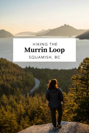
You climb quickly up until you reach Quercus Viewpoint. This is probably the photo you've seen from here. It has an epic bench and a big exposed area that looks out onto the sound. This is a really great sunset spot, but if you stay until dark here, don't attempt the rest of the hike in the dark; just take the short route out using Murrin Loop.
Just a bit past Quercus Viewpoint, the loop trail comes to a fork where you can branch off onto Jurassic Ridge. This is an optional part of the hike. It arches up higher and takes you up to another taller viewpoint before meeting back up with the main loop trail.
Is it worth it? If you like hiking, it's definitely worth it. You get a view of the sound from higher and can see Howe Sound spread out below, flanked by mountains on both sides, with islands dotting the water and the old Woodfibre Mill visible across the inlet. On a clear day, you can see all the way to Vancouver Island. For 90 minutes of effort, it's hard to beat.
It's a great, little challenging loop. It's not that long, so you don't need to be too fit to take it on, but there are some really steep parts, some scrambling required, and 3 different sections where you will need to use ropes. If that sounds awful to you, don't worry, because the view from Quercus Viewpoint is mostly the same.
For a hike this short, the terrain is surprisingly rugged, with roots, rocks, ropes, and a few sections where you'll be scooting down on your bum and wondering if you should've just stuck to the easy loop.
Bail Option: From the Quercus Viewpoint junction, you can continue left on the Murrin Loop Trail and skip Jurassic Ridge entirely. This brings you back to the parking lot via a gentle forested descent, cutting the hike down to about 2 km total with minimal scrambling. If you're hiking with kids, older family members, or anyone uncomfortable with exposure, this is the move.
If you're committed to Jurassic Ridge, continue past the Quercus junction and watch for the next signed junction about 300 meters ahead. Turn right toward Jurassic Ridge. This is where things get interesting.
Why Hike Murrin Loop & Jurassic Ridge

Jurassic Ridge makes you question the "effort-to-reward ratio" of bigger, longer trails. Sure, the Chief offers better views and more bragging rights. But it also takes twice as long and beats your knees into submission. Jurassic Ridge gives you granite ridges, sweeping views of Howe Sound, and enough scrambling to feel adventurous, but all in under two hours. For people with limited time or energy, it's a no-brainer.
The technical sections add personality to what could otherwise be a forgettable forest loop. The ropes and ladders aren't just gimmicks; they're legitimately necessary to navigate the steep granite sections, and they give the hike a bit of edge. You'll feel like you did something more than just walk uphill, which is satisfying.
The views are the real payoff. Howe Sound is one of the most photogenic inlets in BC, and Jurassic Ridge gives you a front-row seat without the multi-hour grind. On a clear day, the layered headlands stretching into the distance look almost surreal, like a topographic map come to life.
That said, this isn't a backcountry experience. The parking lot is right next to the highway. You can hear traffic on the 99 for most of the hike. The trail gets crowded on weekends, and you'll likely encounter other hikers at every viewpoint. If you're looking for solitude, go somewhere else. But if you want a quick hit of granite, views, and scrambling close to Vancouver, Jurassic Ridge delivers
When to Visit Murrin Loop & Jurassic Ridge

- Spring (April to June): The trail is hikeable, but mud and wet rock make the scrambles more challenging. If there's been recent rain, the granite slabs on Jurassic Ridge will be slippery and potentially dangerous. Spring is better for the Murrin Loop without the ridge extension.
- Summer (July to September): Peak season. The weather is dry, the views are clear, and the trail is in perfect condition. Expect crowds, especially on weekends. The parking lot fills up fast, so arrive early. This is the best time for the full Jurassic Ridge experience.
- Fall (October to November): The crowds thin out, the weather is still decent, and the fall colours add a nice touch to the forest sections. Rain becomes more frequent, so check the forecast before heading out. The granite can be sketchy after wet weather.
- Winter (December to March): The trail is technically hikeable year-round thanks to its low elevation, but winter brings rain, snow, and ice. The roped sections and exposed granite become significantly more dangerous in these conditions. Only experienced winter hikers should attempt this trail during bad winter weather. But during a stretch of nice weather, this becomes one of the easiest winter hikes around Squamish.
FAQ
How long is the Murrin Loop & Jurassic Ridge hike?
Is Jurassic Ridge difficult?
Can I hike Jurassic Ridge with my dog?
Should I hike Jurassic Ridge clockwise or counterclockwise?
Can I hike Jurassic Ridge in the rain?
How do I get to Murrin Provincial Park?
What time should I arrive to get parking?
Can I skip Jurassic Ridge and just do the easy loop?
What should I bring for Jurassic Ridge?
Is Jurassic Ridge good for kids?
When is the best time to hike Jurassic Ridge?
Are there facilities at Murrin Provincial Park?
Can I swim at Browning Lake?
How exposed is Jurassic Ridge?
Our Trusted Travel Partners
We only recommend products and services we personally use and trust.

SafetyWing
Travel medical insurance for nomads and remote workers
Booking.com
Find the best deals on hotels, apartments, and vacation rentals
AllTrails
Discover hiking trails with detailed maps and reviews
Surfshark
Secure VPN for safe browsing and accessing content worldwide
Get Your Guide
Find the best deals on tours and experiences
Airalo
Prepaid SIM cards for travelers
Trusted Housesitters
Find free accommodation by house and pet sitting worldwide
Wise
Send and receive money internationally with low fees* We may earn a commission when you make a purchase through our affiliate links, at no extra cost to you. We appreciate this support, which helps sustain our blog and allows us to create more content and help more great trips get planned!